
The Rural Cycling Highway
Most of us have probably heard of cycling highways in the Netherlands. These long distance segregated bicycle paths run through suburban and rural areas, making it easy for cyclists to commute into cities and towns. Perhaps less known is that cycling highways also exist elsewhere - for example, in Northern Ireland. Considering NI is not especially famous for its cycling infrastructure or high rates of bicycle commuters, I find this interesting and would like to share my experience.
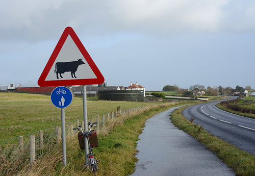
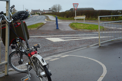
The place where I am currently staying is about 7 miles from Coleraine - a good sized town by local standards, with multiple shopping centers, a variety of businesses, and a university. It is a major commuter's hub for surrounding rural areas - including the village I am closest to, which is Castlerock. There are two routes from Castlerock to Coleraine. The direct one is along the A2 - a country highway with high speed traffic. The indirect one is along a quiet backroad that meanders along the coast and is quite hilly. When I am on my roadbike riding for sport or recreation, I prefer the hilly backroad. When I need to get into town in my regular clothes, laptop in tow, without being absolutely spent and dripping with sweat upon arrival, the comparatively flat and more direct A2 makes more sense. Luckily, a fully segregated mixed use cycling/pedestrian path runs along the entire length of the country highway.
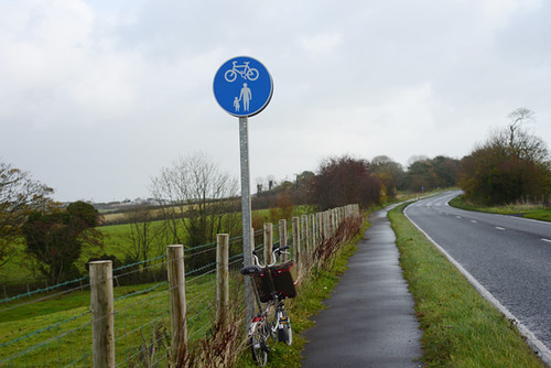
The path is wide enough to accommodate 2-way bicycle or pedestrian traffic. It is buffered from the road by a 3 foot wide grass strip and a raised ridge. The tarmac is a well maintained chipseal. Blue MUP signs as shown here are posted every half mile or so.
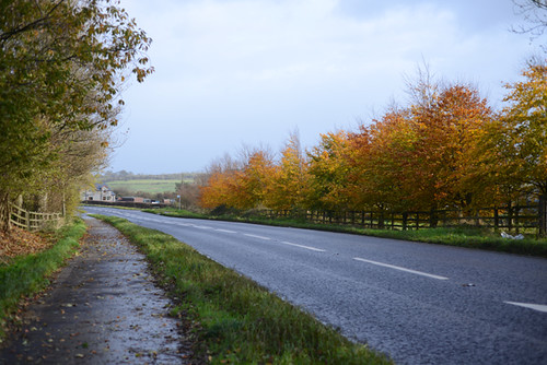
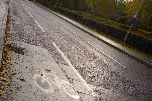
One of the nicest things about this path, is how few interruptions there are. I only counted about 3 during the entire 6-mile rural stretch before hitting the Coleraine suburbs.
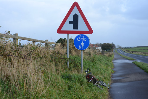
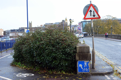
In the more populated areas, the intersections look like this - but navigating them is intuitive, and it's easy to watch for traffic.
Once in the suburbs of Coleraine, the segregated path transforms to a bike lane. At this point an additional two-way MUP appears across the road.
Once in the town proper, a segregated bike path takes you over the bridge across the river Bahn into the town center - a largely pedestrian area closed off to motor vehicle traffic. And so before you know it - voila, you arrive in the city after a very pleasant commute from the countryside.
Overall, I would say the most challenging aspect of the cycling highway here is the weather. In mid-November, it is getting cold, bleak and damp, with strong winds. The landscape here is wide open, with little in the way of shelter from the wind or rain. Another thing to note, is that - for the most part - there is no illumination at night. The structured and straightforward nature of this route makes navigation in the dark doable with bright LED lighting - but not everyone will like the spookiness of riding through the middle of nowhere in pitch dark.
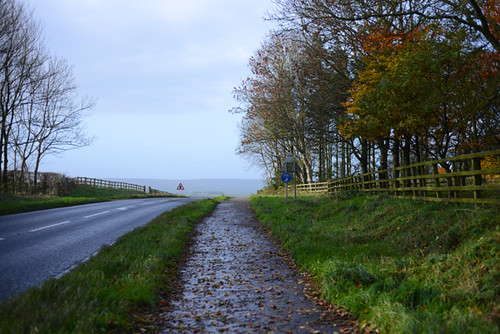
As far as the nicest parts of the cycling highway, it is things like this. Riding along the segregated bike path, I can take it easy and enjoy the scenery and animals. It is a pleasant and relaxing way to get around for transportation.
The cycling highways in Northern Ireland exist without much fanfare. But they are here, and they are lovely. If others have experienced cycling highways - either in the Netherlands or elsewhere - I would love to know your impressions.
looks nice. Cold, damp and dark here as well, Much nicer on a bicycle.
ReplyDeleteBack in the early 90s I spent 3 weeks going around Denmark using a national cycle route map. Back then it was a world away from why we had in Ireland. I did a big loop from Copenhagen with ferries, trains and even a bus. I got upto to the very tip of Skagen and dropped into Odense on way back. I can't imagine what it's like now but back then to traverse a country on sign posted routes through forests etc. was wonderful. I dont remember ever getting lost.
ReplyDeleteImpressive. How many other cyclists do you typically see on this path?
ReplyDeleteIt seems to depend on time of day. For example, yesterday I rode into town and back early morning and saw maybe a dozen. Today I rode in at noon, returned at 3pm, and saw none except close to the town itself.
DeleteHi,
ReplyDeleteI'm currently studying in Germany and I can say that the "cycling highways" (Fahrradwege or literally bike paths, I don't know if they are highways like in the Netherlands) here are pretty good, at least according to my standard. Usually they are more than two bike wide and pretty well maintained. I think you can be 100% sure that there are always highways connecting the big cities.
Some examples in the Bundesland of Thuringia: http://www.thueringen-tourismus.de/urlaub-hotel-reisen/radwege-in-thueringen-120004.html
PS: and here in Germany was I able to ride a bike for the first time in my life. Thanks to you and your blog among several others which have inspired me!
Did some of those back in the 90s too. Followed one down the Danube to Rothenberg. Did get lost in that trip in Thuringen on way to Erfurt to visit Wartburg. It wasn't long after reunifation. Fond memories now.
DeleteI've actually experienced very few, other than dedicated and separate bike paths between reasonably close towns in Oregon. It was then (late '70's) I decided it was time to get good lights for my bike because the path wound through long stretches of woods and fields which were unlit. I believe a route is being built along the Columbia Gorge which will allow cyclists to connect from Portland to Hood River (sixty miles)....Also, reading journals from CGOAB there seems to be many of these scattered about the U.S., some adjacent to roads and some totally separate. I think it's smart planning, promotes tourism and healthy, happy, populations.
ReplyDeleteI think that path looks great! I always look for a path with few intersections because otherwise it is miserable and you are better off on the road. I hesitate to call it a highway, though, if pedestrians share it. Is that how the ones in the Netherlands are?
ReplyDeleteYou're keen riding in today - I got blown off my bike last night and resigned to today being a baking day!
ReplyDeleteI wouldn't go out on my roadbike today, but the Brompton does pretty well in cross-wind gusts. The worst part was the super-strong headwind, uphill, on the way back. Fun : )
DeleteCycling highways like these are especially nice in the rain, which is bad enough without having to swerve out into a lane to dodge puddles or worry about visibility and being constantly splashed. I wish there were more connecting communities.
ReplyDeleteComing from the Netherlands, it's easy to forget how spoiled we are with our biking paths and get annoyed with stupid intersections and traffic lights that always seem to favour cars... Until you go to Belgium or even Germany. Yes, they have nice bike paths as well, but in Belgium there is a lot of sharing the road with cars that drive too fast and too close for my comfort. And in Germany, bike paths tend to stop all of a sudden, and you'll have to cross the road to continue. Or they merge into sidewalks. In France, a cycling route even took me onto the hard shoulder of a highway. Not a safe feeling.
ReplyDeleteAnother thing about traffic in the Netherlands is that it is not just about cycling lanes, or even 'cycling highways'. Many of the smaller roads have a reasonably speed limit, of 60 km/h -- so you just know most car drivers will not try and use those roads as alternatives for the highways, where they can drive at least twice as fast.
ReplyDeleteEven cycling there never feels that dangerous [ -- though just some moments ago a van overtook me on my cycle on such a road, just before a bend, and nearly drove into another car].
Cycling highways: other than making use of MUP within cities or suburbs, it's the shoulder or nothing along highways in most of North America. There is a feeble bit of separated path in my area along the highway but for whatever reason was never finished and only covers a few 'rural' blocks. Most cyclists in my area are mountain bikers and will avoid the highway at all costs. There are ways to get around higher up the mountain but require some exhausting climbing and I haven't got the bike for it right now. There is an alternative 'highway' of old logging roads that they use. If they were more accessible to road and commuter bikes I'd be on it, but it's kind of secret and I would have to backtrack considerably to use them.
ReplyDeleteThe Victoria, BC area has an extensive separated bike/pedestrian network, and trails like the Galloping Goose cover something like 70km taking you out of the city into surrounding areas. It does not follow the highway though(maybe briefly) is completely separate following an old rail line.
Your bike highway looks well designed with few interruptions which is key to a functioning bike path.
Oh sounds lovely cycling in the dark like that. I live in a rural area(but not rural enough), so am used to it.
The Galloping Goose and Lochside trails are a great asset for our weekend rides when we're happy to go where the trail takes us. If only Victoria/Sannich had a bike path that paralleled the highway into downtown for commuters.
DeleteQuebec has a large network of cycling highways, Les Routes Vertes. Some are green paint on the shoulder of highways, with 2 way (so one direction is wrong-way) slightly separated, bike lanes. Some are lovely, completely separate paths through woods and by rivers, complete with bicycle higway patrol (patroleurs) with first aid kits and tools. Entering Montreal from the west, there was even a staffed welcome center on the bike path, with maps and lodging recommendations, and a bike-pump.
ReplyDeleteHere in Seattle we have a number of former railroad tracks that have become lovely cycling and jogging paths.
ReplyDeleteWe also (had) a mayor who was very much supporting cycling and put in a good many bicycle lanes throughout the city. But then he lost this recent election... and I'm guessing the loss was in no small part due to motorists who were irritated at having to share the road with bicycle lanes. I'm curious if the new mayor will have the lanes reduced.
Your photos in this section look so rural and almost forlorn. Maybe it's just the weather. Glad you took a break from the blogging to get things straight. Hope the art making is going well. Making art is always a nice diversion from cycling.
:0)
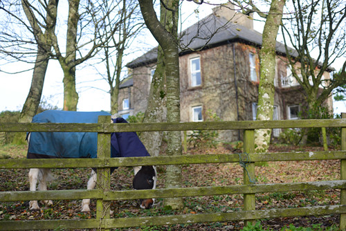
I live in Montana, where road signs declare vast expanses of the countryside as Open Range. In other words, you're almost guaranteed to find livestock running loose on the road. With that in mind, the sign in the first photo seems to be warning of a Cow Crossing, or perhaps "Dairy Ahead." Bur for the life of me I can't out the meaning of the sign in the fourth photo. Perhpas it means "Grain Elevator Ahead"?
ReplyDeleteWhen I was a boy there was a marvelous path, not unlike this one, from our home to the mine where my brothers and I were indentured. It was just another part of an idyllic boyhood we took for granted and now look back wistfully upon.
ReplyDeleteEager to witness another sunrise, we would rise about half past 4, dash through the leak in the roof to clear our heads(Oh, the lovely rain we used to have, 3 inches a night and more on holidays, nothing like it nowadays), yank on our tunic and breeches, wolf a bowl of sand and a dipper from the washtub while slipping a woolen cloth into our pockets for lunch, accompanied by a murmured hymn or limerick from my beloved Mother, already in the kitchen busy compounding Gunpowder or sharpening Bayonets for the local Methodist militia, Father resting soundly in the chair by the fire before another day of lecturing at the Train Station.
My brothers and I would rush out the empty door of the shed and leap onto our bicycle, Martin and Myself taking a pedal each as the oldest and strongest at 7 and 8, respectively, Aubrey and Winslow perched on opposite sides of the handlebar, facing backwards and steering by gripping the shoulders of us older boys and pushing in response to Gregor's shouts of "GEE" and "HAW" from his lookout in the basket. Artimis, would sprint from one end of the bike to the other, barking and laughing at any stray dogs that would try to hold our speeding wheel. And Lawrence, poor doomed Lawrence, manfully assisting the progress of the whole enterprise by running backwards on the top of the chain like some fiendish Tightrope Walker. The "little boys" piled on where they could find suitable purchase and shouted encouragement at the top of their wee blackened lungs. At times there must have been half a dozen of them, I'm not sure they all had names but all were firmly in the warm embrace of the family while they lived.
Oh, but the trail! Back to the subject at hand! Our county was crisscrossed by a convenient network of(in descending order of capacity) interconnected paths, trails, gullies, ditches and running swales that with a little familiarity allowed one to reach any point in the area without venturing out onto a paved road(of which there were none). The route to The Pit crossed 11 miles of the most picturesque scenery, through fields of dock and stinging nettle, fording the pool below the Tannery where the swirling waters reflected the sky in scented paisley Technicolor and ascending lofty peaks of slag and dung. This was before the taint of Socialism had spread across our land and each man blazed his own trail, relying on no one to plow, grade, pave or otherwise smooth his path from cradle to grave, as such, when we were confronted with a log or boulder in our way we would alight from the bike, remove the obstacle with our own might then replace the stumbling block in the path for the advantage of the next independent traveler. One great fallen Beech was eventually worn to nothing by a generation of passers-by and had to be replaced with an even larger Oak drug in by 6 teams of Oxen.
In winter, we carried slung across the bikes frame, the families sack of gravel which we would spread on particularly icy stretches, always gathering it back up to be ready for the next frozen patch. Those for whom thrift was no issue would leave their gravel on the trail forcing us to leave the way and spread ours alongside to avoid treading on theirs and betraying the Pioneer Spirit that makes America great. Other families would rely on furs or planks but we took great pride in our connection to the Mining Industry and used naught but gravel.
Wonderful memories of wonderful days, and while, in our joy, we knew not that we were poor, likewise today, in our lives of convenience and ease, we know not that we are Damned.
Spindizzy
That looks like a lovely ride. I tend to get spooked riding at night, but good lights would probably help with that.
ReplyDeleteWhen I lived in Germany - 20 years ago - I used several of these for day trips and longer tours. I loved them; they made me feel like a little kid again with my first bike because they gave me the same kind of "freedom" I felt when I got my first bike and had the run of the neighborhood.
ReplyDeleteAt one point I saw part of a new road being put in; the big asphalt laying machine (for lack of a better word) had a big section for laying the asphalt on the two lane road, then a smaller section for laying a bike path parallel to the road, and then a third section for laying a sidewalk parallel to the bike path. Each divided from the other by 5-10 feet of grass.
How long does this particular path go?
ReplyDeleteI have not found a map of any kind, so not sure. But it's possible that, with some interruptions (where A2 is not a highway and on-road cycling is safer), it stretches from Derry to Coleraine along the A2, which would make it around 35 miles.
DeleteWow, for whatever reason, I got the impression that it was only a few miles long like the Dutch bike highway in the link you provided(and I was still impressed). When I think of what would be linked around here by 35 miles of asphalt laid out in any direction... It would fundamentally change the way we ride our bikes and add such a degree of practicality that it wouldn't require a person to be an enthusiast or someone without any other options to make it part of their normal routine.
DeleteIt makes our little 2 mile Greenway were fighting so hard for seem like pretty small beer.
Spindizzy
Fraid not as much as 35 miles. Derry to the airport is busy dual carriageway, then single carriageway with very patchy (geographically and surface!) ped/cycle provision via Greysteel and Ballykelly to Limavady. Then, the Seacoast road to Mussenden is light on traffic and safe to cycle without the need for specific provision. Just beyond Mussenden, the bicycle highway starts... only about 7 miles I'm afraid from Coleraine.
DeleteI could have sworn I've seen stretches of a similar looking path around Ballykelly and on approach to Derry - are they just very short, unconnected segments then?
DeleteSo one of my projects today on my ride was mapping the MUPs from Derry to the start of the cycling superhighway.
Delete1. Leaving Derry: Caw to Maydown roundabouts. 1.5 miles of busy dual carriageway where cyclists either make like a vehicle or take the footpath.
2. Maydown to Campsie roundabouts: 1.5 miles. No footpath here, so you either vehicle it or share the left side of the white line with gratings and reflectors. Not ideal but doable.
3. Leave the dual at Campsie roundabout and get on the old road. Here (finally) MUP for 2 miles as far as the airport roundabout, though the only traffic is folk visiting the large car sales emporium alongside.
4. Joining the main road, now single carriageway, you're on your own for 1.2 miles, though there is a wide indifferently paved footpath.
5. The Greysteel MUP runs through the village for 1.2 miles.
6. On your own again for about 4 miles, though again a reasonable hard shoulder for peds.
7. Next is the Limavady MUP, running for 4 miles should you chose to take it as far as your favourite sloping roundabout. Soon you're on the Aghanloo Road then the Seacoast Road, both nice low intensity roads with no particular need for MUPs until you join the superhighway just past Mussenden.
So better than I thought, less good than you thought.
That was hard work. I really gotta get out more. Oh wait.....
Looks a nice cycle way, with so much light pollution in built-up areas i find cycling where there are no street lights a rare pleasure, no lighting means your eyes adjust naturally to the ambient light levels.
ReplyDeleteLaurie -
There are a few here in West Wales that are very similar to the one you mention. There's a map on the sustains page that shows them quite well. It also shows cycle routes all over the Uk and Northern Ireland. The one near Coleraine is also shown when you zoom in (or search for Coleraine). Where paths alongside roads are not available, they guide you along quiet minor roads. Probably the best 'almost traffic free' one near us is the millennium path from Kidwelly to Swansea. It's excellent!
ReplyDeletehttp://www.sustrans.org.uk/ncn/map
The kind of arrangement you've shown here is pretty common all over the UK, although this one is unusual because it is actually fairly good.
ReplyDeleteThese design's lack of priority over side roads and the lack of a smooth transition becomes more of a problem when this approach is applied in more populated areas as you may have 10-20 points where you are expected to give way within a single mile, interactions with pedestrians become can too numerous to remain feasible and the surface can become particularly awful where water/gas/electricity mains have been run under the path. These routes are the way they are because they are usually existing footways which have been re-designated with the minimum of changes made.
It is lovely when one of these footway conversions is accidentally quite good, but overall I think we need to look to The Netherlands for infrastructure design which works not just occasionally and by accident.
Following on from my previous comment, I think you might like to look at this page on the sustains site.
ReplyDeletehttp://www.sustrans.org.uk/northern-ireland/national-cycle-network
I have not found Sustrans to be a useful guide, at least not for this area. For instance, the easy MUP route I describe here is not even on their map of "long distance rides." Instead they suggest taking a steep road straight over the top of Binevenagh mountain. The NI Sustrans routes seem to be geared toward cyclotourists, and hardcore ones at that - not everyday bicycle commuters.
DeleteOh dear, that's not very good is it?!! I wonder whether Sustrans are open to suggestions with regard to that sort of thing? I know Google welcome 'corrections' to their maps, then check them out and apply them if confirmed.
DeleteThat's seems to a general problem in UK & Ireland. Those who plan them seem to think anyone cycling in countryside is either a tourist/roadie. Cycling as transport doesn't seem to register. Often tacks aimed at cycling are gravel more suited for mountain bikes. This is very evident in some of the disused railway line routes.
DeleteHi everybody,
ReplyDeleteIn my country some cycling highways are builded on old disused raylroads.
For instance: from bordeaux to Lacanau-Océan, a sixty-kilometre cycle path cross great wood, a kind of cyclist paradise which maybe very pleasant with the randonneur bike like "Royal H" with 650B wheels previously studied in January 9, 2012. I assembled myself a similar bike.
I think randonneur is better than Brompton in this kind of travel.
For long run (60 km one way + 60 km return to Bordeaux) I move part of my body weight on the arms and legs, saddle need to be close to the handlebars level.
Feeling comfortable with long run couldn't be easily applied for everyone: it depends on appropriate setting with body and bicycle.
Thanks.
Laurent (650B fan)
Here is a good website about Bordeaux-Lacanau cycle path (it's not my blog) : http://invisiblebordeaux.blogspot.fr/2012/05/bordeaux-lacanau-cycle-path-from-steam.html
Horrible statistics from London. As a rural cyclist only my ultimate respect to anyone who chooses to get on a bike in that place.
ReplyDeletehttp://www.bbc.co.uk/news/uk-england-london-24954645
Looks concerning from Dublin too, where there a big plans to expand infrastructure significantly. Our equivalent of blue paint is red tarmac. We have banned HGVs in city are, they are forced to use motorway/tunnel. But we still have deaths usually again involving big vehicles like London.
DeleteSegregated cyclepaths are a great idea where the intersection density is low - like the one you show. Unfortunately, the design is used indiscriminately even in urban settings, where they don't work well. Here are some examples from Berlin, Germany, that don't work well:
ReplyDeletehttp://janheine.wordpress.com/2013/07/12/cyclepaths-in-berlin/
Fortunately, they are being replaced by on-street bike lanes that are better suited to high intersection densities.
Really nice post - these are making me want to visit Ireland on my bike more and more.
ReplyDeleteMoving to Milton Keynes a year ago has been the primary source behind me getting into cycling. The city's 'redways', a network of shared use paths, make it really easy to get around the city, which is built on a grid system.
Although the network is/was pretty revolutionary in the UK, a lot of it is rather poorly looked after. The signage and surface of a lot of it leaves much to be desired - although there are rumours that a big investment is beginning around now, and there have been recent improvements and re-surfacing etc.
The other good bit about the redways that struck a chord from your post is that for the most part (if not all?), they are lit. A lot of them follow roads which are lit anyway, but others (including many of the underpasses) are well-lit.
Please define "MUP". Thanks!
ReplyDeleteMixed Use Path - meaning cyclists and pedestrians
DeleteI like the idea of these after being on too many busy and fast roads coming into towns on tours and exploratory rides. We would need room and money to develop them here but you they would be useful.
ReplyDeleteBTW Colrain in western Massachusetts might be named after your Coleraine. At least the spelling is the same as on a nineteenth century map I have in my dining room.
I guess things are just bigger here in Los Angeles. There are separated MUPs along the rivers and the coast, which have been here for years. I live near the one in Santa Monica, which runs about 26 miles. Then there a gap and it starts further south in Long Beach - don't know how far that one goes; at least 15 miles to Newport Beach. These connect to the river paths. Today I had a pleasant ride down most of the Ballona Creek path - about 12 miles. There are longer paths from the San Gabrial mountains to the sea near Long Beach. Plenty of places to explore, separate from cars. Of course, none of them connect well to centers of commerce, but things are improving, and new cyclepaths are appearing.There are also lots of those 2 mile short path projects around the area.
ReplyDeleteLA is adding some along the new light rail trains, but as mentioned above there are some problems in using them for distance cycling. There are gaps, and stops at intersections that don't favor cyclists. Still there are many routes here.
Non are very dark at night and it usually doesn't rain!
I went last year on holiday in Amsterdam and I saw a lot who loves to cycling, so I did it too. It was really nice in the fresh air and Amsterdam is a really nice city.
ReplyDeleteThe apartments in amsterdam were really nice too!
Some of the Los Angeles paths Eric mentioned are useful--Ballona Creek offers access to every major road it crosses, and a couple of minor ones, and I use it frequently. However, many of them were built with roadies in mind and have little access to the communities they pass through.
ReplyDeleteWestern US cities tend to favor riverside paths; here's a short post I wrote comparing fairly equivalent facilities in Denver and LA:
http://www.bicyclefixation.com/blog/archives/00000784.html