
A Dabble in Route Planning

The past year has been a great eye-opener for me as far as finding new places to ride in an area I thought I'd exhausted. In particular, I've been impressed by local randonneuse Pamela Blalock's ability to design routes entirely along back roads, with minimal motorised traffic. This style of route involves more climbing than typical, and, at times, some intense navigation. But having gotten used to both, I've come to appreciate the opportunities routes like this provide: to travel on my bike largely undisturbed by cars, and to truly get to know an area, with all its hidden scenery and useful shortcuts. I also appreciate that Pamela's routes are not a matter of luck or psychic powers, but of dedicated research and strategic exploring.

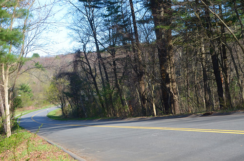
Until recently I did not feel sufficiently confident in my navigation skills to try this myself, but now that is changing. I am planning a ride heading North, and getting out of Boston straight up the coast is a thoroughly unpleasant business. There is no good way to do it; for the first 10 miles it is all dangerous roads and lots of congestion. So I wanted to plan a route that would swing out west and come around from there, connecting to the northern route at a point where it calms down. This adds about 30 extra miles to the start of the trip, but I will take 40 pleasant miles over 10 unpleasant ones any time.
In planning the westward route extension, my goal was to try and do it along lightly traveled back roads, possibly with some unpaved stretches. I started by studying similar routes that go through the area, combining and modifying them based on personal experience, maps, and educated guesswork, until I'd strung something together that went where I needed it to go. I loaded the route onto GPS, printed out a cue sheet, and got on my bike to test out my handiwork.
For my first time trying something like this, it wasn't bad. There were lots of turns that would drive some people nuts and a few awkward climbs - the kind where a climb starts right after a sharp turn, catching you by surprise, so that you're downshifting madly from a high gear. This I didn't mind, particularly since I was the only vehicle on the road much of the time. But there was also a couple of mistakes/ surprises - not necessarily bad, but educational.
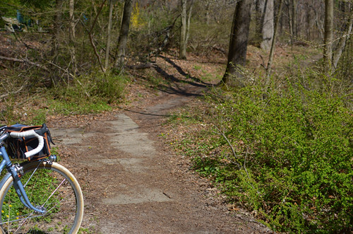
My route included a few unpaved trails, all except one of which I was already familiar with. The one I was not familiar with turned out to be more technical than I'd expected.
A shortcut through the woods, the narrow bumpy trail wound its way downhill between trees rather tightly. I was able to ride it, but made a note to avoid it on skinny tires, in wet weather and in the dark. Looking at the map, I saw there was a way to circumvent the woods on the road, so I then went back and tested that stretch to make sure it was a sufficiently traffic-free alternative.
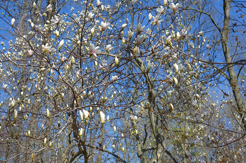
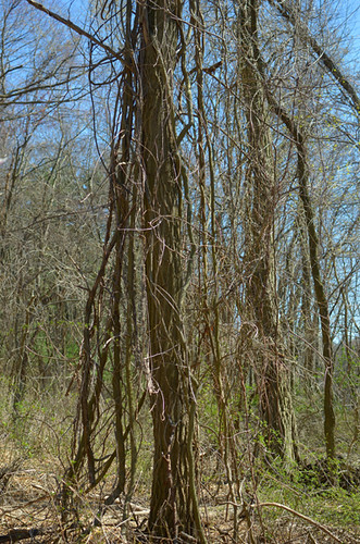
While not ideal for all bikes and all occasions, this trail proved to be incredibly scenic this time of year. For much of it, I cycled under a canopy of budding magnolia blossoms. The sun brought out their colours against the blue sky, and the warm weather brought out their scent.
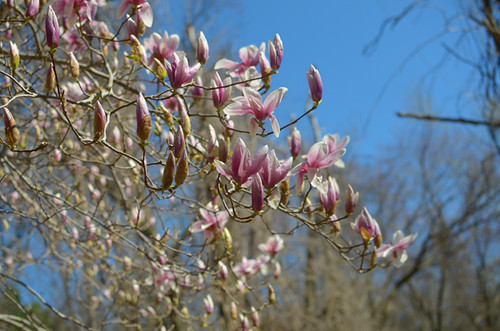
Riding here, I felt as if I'd been gifted a rare glimpse into something special and rare. Only for 2 weeks of the year do these flowers blossom. And all it takes is one windy, rainy day, for all this tentative pinkness to be stripped off its branches before the flowers even fully open up.

Spring is such a delicate time of the year. The greens are pale, the tangled trees are transparent like lace. In the summer this will all become fuller, heavier, thicker - a dense fabric.
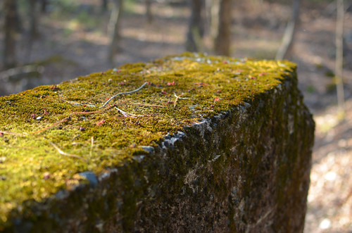
Even moss is paler and softer. I love coming back to the woods season after season and seeing it all change.
Further along, I found myself on a stretch of road that was much busier than expected. So I changed course in hopes of finding a better alternative. On the map I saw a tangle of side streets that it looked like I could ride through to get to my next point, skipping the busy road. So I did just that, and found myself in a cul-de-sac neighbourhood situated on a substantial hill. Looking for the best route, I ended up going over this hill several times from different directions, until I found the sequence I was happiest with.
On one of the streets I passed a group of small boys with their kids' bikes. The poor things could only ride them up and down short stretches in front of their house before the road became too steep. Seeing me continue all the way up the hill, the boys stopped what they were doing, stood still and stared, saying "Whoa, I want to do that!" and "That's a nice bike, lady!" They had not reached that age yet where youthful mockery becomes hard to detect; it was clear their delight was genuine.
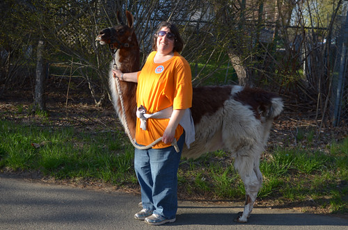
Later, I encountered a woman walking a llama, as casually as if she were walking a dog. Normally I am not good at making quick u-turns, but this time it was no problem (llama!).

Heading home along a quiet trail, I realised that in the course of the past 50 miles there had only been a few stretches with noticeable car traffic. And now that I had a better understanding of the neighbourhoods around those stretches, I could make changes to improve those parts as well. It wasn't perfect, but I am pretty happy with my first serious attempt at backroad route planning. Even the parts that did not go as expected allowed me to explore and discover interesting pockets I would have otherwise missed.
Having a network of new, "secret" as some locals refer to them, routes through familiar areas is extremely exciting and a great way to travel. I am looking forward to doing more of this!
Apparently no encounters wit dogs? Sometimes when venturing off the beaten path around here I discover unleashed dogs who like to give chase and I'm scared to death of them. Danger for me is in dog form rather than car form :)
ReplyDeleteI think this depends on your area. In and around Boston, my worst encounters with dogs have been on MUPs. Otherwise, I've had a couple of dog encounters in NH and VT, but not on any of the local back roads, so far.
DeleteI just think it's interesting how fears can dictate our decisions and actions. I've beaten off a mugger, had things thrown at me from cars but didn't flinch, but dogs will paralyze me....in my urban area they are alway on leash but outside of that they roam and prance and mess with potential prey or playmates called bicyclists! So I now only venture out into those places with others.
DeleteAround here dogs generally learn pretty quickly what cyclists are and mostly leave them alone, the way most of them ignore most cars most of the time. In more remote areas, dogs haven't seen enough of them to figure out what they are. Also, more places have leash laws and enforce them, so most of the time dogs that are apt to chase are chained up. On the other hand, roads are narrow and winding, so cars can be a hazard even when everyone is being polite.
DeleteI did a long ride in West Virginia last year and it was completely the opposite. While there was usually plenty of room on the road, I think I got chased by every single friggin loose dog in the state.
I rode from the Detroit area to Halifax, Nova Scotia on blue highways and back roads. Many dogs. Two takeaways: 1) all dogs learn the Calculus in the womb (they've got the whole slope/intercept piece down); 2) Always have 3 or 4 tennis balls in your handlebar pack. Just as the do is hitting the shoulder of the road, heave one gently over your should and Rover ALWAYS went for it.
DeleteAs a reader of 'crazy guy on a bike' i find it funny how many posters comment on the dogs of Kentucky. Apparently it's hard to avoid them, even on the main routes.
DeleteAnon 1:38 - To be clear, it's not that I'm scared of cars or busy roads. I commute on some of the busiest roads in town all the time, it's fine. It was just such a revelation how much more *pleasant* and enjoyable the quiet, fresh air, back roads are in comparison.
DeleteI LOVE the idea of some unpaved light gravel travel. I am leary of venturing a few miles to someplace where the road may be a little washed out or too muddy to stay upright on.
DeleteI am a little aprehensive about the whole wild animals thing, my friend Karen from PA likes to tease me and say, "Oh yeah, you'll hear a deer before you hear a bear!" YIKES! The tennis ball idea I think is pure genious, probably better than a piece of rebar... and lighter too. All I have to deal with around here are I-Pod zombie pedestrians and taxi cabs etc. A different kind of assassin.
vsk / Brooklyn, NY
Hey! I saw the woman with the llama on my commute home yesterday. I'm so pleased that you've posted photographic evidence so that people don't think I've completely lost it.
ReplyDelete: ))
DeleteI've seen them before. But this is the first time I was able to whip out my camera and get them! I want to believe.
This looks like a great route, envious.
ReplyDeleteCan't imagine that Lezyne is the best pump for your hands, but .COM on the seat bag is a nice reminder we're living in the 21st century.
Surely that's not a picture of the technical section is it?
On the technical section I stayed on the bike : )
DeleteBut not sure technical is even the right term, I can never tell. Narrow, winding, bouncy/big rocks, prone to mud. For wide tires and not in the dark basically.
Impressive!
DeleteTechnical is subjective; I wanted to make sure you weren't backsliding.
I think I've told this before: there is a woman here who used to walk her Mastiff with a miniature horse. Not cute.
Additionally a full frame pump makes an excellent dog jousting spear.
DeleteApparently a Lezyne is what you get when it's done chewing.
They make a larger one that I'd like to try, but apparently it isn't much more functional than the one shown (which is fine to use actually, just takes forever).
DeleteThat looks like a beautiful ride. Despite having lived in the South all my life, I'm still afraid of running into a crazed redneck (perhaps in a pointy, white hat) or a backwoods meth lab. Because of that, I tend to avoid remote roads I don't know. I should get over that.
ReplyDeleteThe most beautiful roads in these parts are strewn with confederate flags, gun clubs, and loose dogs, but they are so worth the risk.
DeleteWhat a quick student you are of many things, how confident you have become as a cyclist, and what an instructive, accessible, and generous model you give us. Thank you. Jim Duncan
ReplyDelete"They had not reached that age yet where youthful mockery becomes hard to detect; it was clear their delight was genuine."
ReplyDeleteThat line made my day, thanks! Those people can be difficult to figure. Seems you got a good early bunch, just the right time!
p.s. llamas...don't see very many out and about in my city, maybe because one is required to bring along a plastic bag when walking an animal.
Lovely! Unfortunately where I live there are few roads or trail alternatives to the busy highway. It would be interesting to go through the route through the year.
ReplyDeleteI saw the same person with her llama yesterday on the Minuteman.
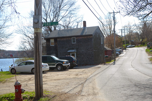
ReplyDeleteIs the last picture the Bedford Narrow Gauge Trial?
That llama gets around!
DeleteYes, the last picture is the Bedford Narrow Gauge Trial, near Billerica. It's beautiful there right now, just starting to turn green.
Nice ride.
ReplyDeleteAnd nice llama.
Curious what GPS you use and if you like it? I'm considering getting one as I'm starting to get more into off the beaten path riding and touring.
ReplyDeleteI have a Garmin 800, which is a cyclo-computer and GPS unit in one. Got a great deal on it, purchased bundled with my roadbike. Otherwise I doubt that I would own this device, which is why I am reluctant to recommend it.
DeleteMy impressions: It is useful for navigation and directions as a sort of live map that shows you where you are and what's coming up, including turns and curves in the road. Especially when I do an unknown route, I like to use it for that feature. Also, if you do a spontaneous ride and end up somewhere interesting, it records it, and you then have that route saved. However, the Garmin's software is downright treacherous. I am pretty good with computers, devices that require programming, etc., but this thing is in a class of its own. Because of the occasional mess-ups, I always like to have a paper cue sheet with me in addition. Also, if you plan to multi-day tour with it, be aware that these units need charging daily.
As you say, some people, like Pamela B., have a real knack for stringing together roads to create a great riding experience. I often ride with a guy I call The Human GPS. He spends a lot of time working on routes that avoid traffic, that often include a bit of dirt, that are scenic, and have a well-placed food stop or two. He's only been riding in the area for a couple of years (he's an Englishman via NYC) but he puts most locals to shame in terms of his road knowledge. He can adapt a route on the fly, too, if someone needs to bail or wants to add a few miles.
ReplyDeleteMy skills are somewhat less impressive, but I do like to go out for an exploratory ride, then come home and check the maps to see where I've been. I find this helps my retention for future reference, too. Plotting out a course is enjoyable, not only for the sense of achievement, but the experience of having road names and cue directions unfold before you.
I'm always amazed when I'm riding with a *local* who tells me I have just taken him or her on a road they've never been on, despite living just a mile or two away. It's funny how some folks are happy to do the same route week after week, on the same busy main roads. I'm happy that I'm having a good influence on you and that you are out there exploring now! And you are doing exactly what I do at times. I'll map something out, then load up GPS and grab a Rubel map and go try it out. I spent ages riding all around parts of Quincy and Milton last fall trying to find the best and quietest route for our Christmas Day ride. By the time we did the ride, I had left no street unridden in a couple of neighborhoods. I try to do this on my own, so as to not subject my riding buddies to less than perfect rides, but I do have a few tolerant folks who don't mind exploring. Now I know I can add you to the list :-)
ReplyDeleteAm curious, how do you 'study similar routes', what software do you use? or is that the garmin as well?
ReplyDeletethx, Summer
I use Ride with GPS online. It is free and does not require you to have a gps unit; you can design the route (or look at others' routes) and then use it to print a cue sheet. But if you do have a gps unit, you can download the file onto it.
DeleteIf you are ever in the Mid Atlantic, and are looking for a fun miltiday ride, as of a month from now the entire length of the Great Allegheny Passage and the C&O Canal Towpath will be open from Pittsburgh to Washington DC. Route planning is rather trivial, but logistics planning is key since it quite remote. The May time frame is best for good weather and fewer crowds. And the picture opportunities are limitless! See https://www.youtube.com/watch?v=dAF1MKcsVMQ (2013) and https://www.youtube.com/watch?v=VpbFMijxs_s (2012)
ReplyDeleteI use ridewithGPS as well and have wondered if there's a repository somewhere of trustworthy sources (users of that site) for routes, or of routes themselves, in the Boston area. There are *so many* routes on there and it's hard to know which ones are worth trying.
ReplyDeleteI'm still waiting for a comment beginning with 'back in the old days...' or maybe those folks are still lost in the woods :)
ReplyDeleteBack in the old days I would use state highway maps and sometimes imagined roads. I once followed a road headed south on the west side of Mount Greylock with my brother. He wasn't convinced that it would lead to Route 7 but I thought there must be a way through but wasn't shown on the state map because the scale. The road turned to dirt then to a trail and I remember carrying our bikes through some sections and then back to dirt road then pavement again. But we did get bit by a lot of mosquitos. I could have used a 1:24,000 topo sheet but they were hard to carry.
ReplyDelete