
Mapping Enchantment

A couple of months ago I decided it would be nice to get ahold of some Ordnance Survey maps, and I set out on a quest to purchase them. Like most things here, this was not without its share of adventure. At the local book shop the salesman looked at me like I had two heads. "Ach no," he said, "you're best to get them online." So I tried online, and sure enough there's a special government website that sells them and it all seemed straightforward enough …until their payment system deemed my debit card suspicious and then not only could I not order the maps, but a fraud alert was activated and I could not use my bank card for days.
The very next day I cycled there. The salesman nodded at my request so matter-of-factly you would think Ordnance Survey maps were the most natural thing in the world to ask for. I followed him around the store to a cavernous section in the back where he stopped beside a dauntingly overstuffed shelving unit. A subtle flicker of gratification illuminated his face when I looked duly impressed, and I wondered how often he got the opportunity to lead someone to this tremendous cache.
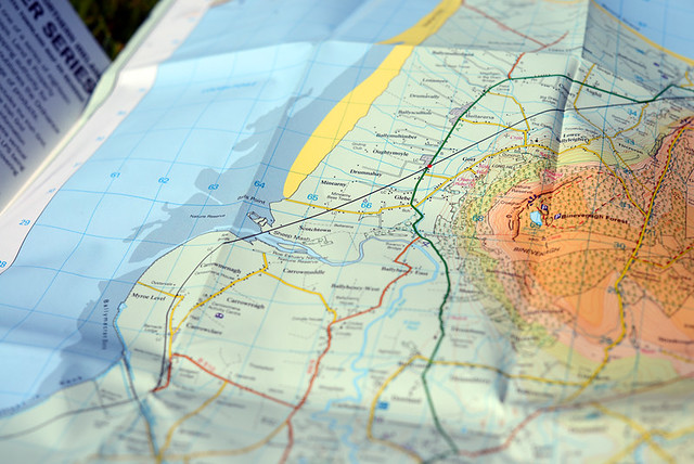
Done to a scale of 1:50,000, the maps were numerous, each covering a tiny section of the region. I could hardly decide which I wanted as they were all so lovely and shiny and the covers featured alluring photos, one more scenic than the next.
In the end I bought four maps that covered the areas closest to me. Clutching them to my chest like a bouquet of flowers, I carried them out into the town square. Then I spread them out on the stone bench and let out a sigh of happiness. What was it about these things that caused such emotional stirring? I had used maps before, for heaven's sake. But in these, there was something particularly enchanting.
In the UK and Ireland, Ordnance Survey agencies put out maps beloved by walkers and cyclists for the level of detail and topographical information they provide. I wanted a set for the purpose of finding local trails and hidden right of ways to use as shortcuts when cycling through the region. Perhaps I could even piece together some local unpaved routes.
My impression from stumbling onto such routes organically so far, had been that unpaved stretches existed, but were disjointed. Having studied the maps, this has proven to be more or less accurate. Unfortunately there is no cohesive network of trails running through the area where I live. But there are lots of individual fragments here and there - considerably more than I had thought. And in many cases they can be combined with quiet back roads to make for a cycling experience that's scandalously scenic and very nearly traffic-free. Discovering the local trails and rights of way also provides access to many interesting locations and landmarks that cannot be reached otherwise.
In a practical sense, this has certainly been useful. But the maps have affected me beyond that. Profoundly altering the way I see the landscape, they have deepened and texturised it. It is as if the information gleaned from their dense markings has integrated with my sensory experiences to form a rich hologram, so that when I look at a stretch of land in front of me it has a luminous transparency that can be activated at will. Not only am I aware of all the backroads, and of the trails beyond those backroads, and of the hidden nooks and crannies beyond those trails, but I am also aware of how they all connect, interact, diverge. The through-ways and the dead ends. The lands that back up onto each other without quite touching. The woods with clearings and without. Bogs that can be criss-crossed and bogs that cannot. Paths rendered invisible by tall wheat. Shallow ledges that make for secret river crossings. Remnants of stone walls, buried under a crust of rotten leaves, that can be used as directional guides. Beyond and within what's in front of me, there are layers upon layers.
As I pedal through my surroundings, neither the distances nor the views have changed, and the textures beneath my wheels are familiar. Yet there is an unprecedented newness to it; the fluttering secret excitement of having gained access to a new dimension.
I like to cycle and then look where I went on Google Maps. I remember the trip better that way. Perhaps your maps could do the same for you.
ReplyDeleteIntriguing! What would be the equivalent in the US, are these basically topographical maps?
ReplyDeleteUSGS 1:24,000 or 1:62,500 scale topographic maps. They have always been easy to obtain.
DeleteI totally get what you mean :-) I'm an architect but I've worked for cityplanning authorities in the past and have been amazed at how much information is contained within ordnance survey maps. To me drawings and maps now offer a much deeper meaning than can be gleaned at first. I consult a lot of different types of maps in my work and find that just about any information, from soil fertility to pinpointing the location of an endangered flower species, may be contained within a map. Quite amazing, when you think about it:-)
DeleteWith rare exceptions US lacks ancient rights of way to map.
DeleteI have a GPS. I refer to Google maps for routes and distances regularly. But when I want the romance and excitment that goes with planning a cycling trip you can't beat maps. Shiny paper leading your imagination down back roads and if you have good ol' OS Maps you'll even know the highs and lows and be able to plan a sandwich with a view. I love spreading the maps across the carpet and letting my mind wander. Virtual maps just don't cut it!
ReplyDeleteYes, ordinance survey maps are wonderful. I can sit and read them for hours, discovering things, like holy wells and earthworks in fields that I know well. I say, “there is no ruins in that field”, go to check and every time discover that the map is correct and I am wrong.
ReplyDeleteIt's deeply involved with the early stages of the modernization of Irish society. For military reasons, Ireland was mapped before the UK by the artillery regiments of the British army. That's why it's called Ordinance, meaning cannon.
Heights were measured from a data point set by Captain Bligh, (yes, Captain Bligh of Mutiny of the Bounty fame), on the base of the Poolbeg lighthouse outside Dublin.
This was the first time Irish place names were written down in a systemic way. Some were given English names, others anglicised Irish names. There are also quite a few names where the only reasonable explanation for the resulting name is that the recording officer was either drunk or deaf!
If you can, go to see Brian Friel's play “Translations” which deals with the struggles of the time. The love scene where Maire and Yolland, lacking a common language, whisper placenames to each other as endearments is wonderful and astonishing. When Hugh, the elderly drunken schoolmaster, recites the townland names in Irish for the last time the world stands still.
I know what you mean! Did you also look at the O.S.1:25000 series? They show so much detail. Even the hedges and field boundaries are clear to see. They also show some minor paths that might not appear on the 1:50000. If you go here - http://www.tracklogs.co.uk/cgi-bin/publ/user.cgi?obj=support&mod=kbase&view=10892639 - there's a small picture of the same area from both scales showing the difference in detail. Well worth checking out if you haven't already. Following on from what 'Anonymous' said about google maps, I also use the Cyclemeter app on my iPhone when I ride. When I finish it automatically sends me a link to Google maps with my route marked on it and a load of information about speeds, altitude, distance and so on. I find maps fascinating.
ReplyDeleteI want the 1:25000 map for Magilligan, but even the "good" book shop did not sell those and I'm weary of trying online again. Will find a way to procure it eventually I'm sure!
DeleteOh my, I love maps. I have dozens. Old ones, new ones, big ones and even a tiny little one that was hidden under a stamp on a post card from a girl I knew in College. The implied adventure, the romance of the new and unfamiliar, I can't resist getting pulled in.
ReplyDeleteMy thing is U. S. Geological Survey maps. A lot like those Ordnance maps and really addictive once you've started acquiring them. I used to buy them for any interesting place that I might have even the remotest chance of ever visiting. It was on the verge of ridiculous. I'm totally over that addiction now though, I only want the ones that adjoin the ones I already have so everything is cool...
Spindizzy
I love maps, have piles of them, but those ordinance maps sound delightful. I would never trust gps! I like to know my way around. I have good direction, rarely get lost, and maps are a great way to remember the surrounding area, what roads connect to what, where tiny trails are, what hidden gems lurk beyond the hills, so there are always plenty of ways to cycle
ReplyDeleteI love the OS 1:50K maps of the UK and Ireland. I practically wore out my Oxford sheet, and I have a set of the Irish ones from Connemara and the Burren that I got for a bike tour there. I like to pull them out from time to time and fantasize about another tour.
ReplyDeleteIGN (the Institut Géographique National) does excellent French topo maps; however, they are no longer updating the 1:50K series. You can still find them in some stores, but they will be missing recently built roads. The 1:25K series (TOP 25) are excellent but a little too detailed for long bike rides, so I usually end up using the 1:100K (TOP 100) series for France. I was delighted to discover that the IphéGéNie app for iOS allows you to subscribe to the entire IGN topo map series for € 15/year; an iPad screen is a little small for doing long-distance route planning, but it's great for previewing a ride and noting things to see (and potentially tricky intersections) that don't appear on the TOP 100 maps.
Rural France is a great place to cycle, by the way.
P.S. You can view UK OS maps at:
ReplyDeletehttp://www.getamap.ordnancesurveyleisure.co.uk
Irish maps (though not 1:50K) are available at: http://maps.osi.ie/publicviewer/
The NI maps bought by Velouria are from OSNI and are available from a different website than the GB and Ireland Ordnance Surveys:
Deletehttp://www.nidirect.gov.uk/osni-mapping-helpdesk
I've bought their 1:1,250 online maps for planning purposes but these maps are really for professional use and not as evocative as the 1:50,000 paper maps.
I find the history of the early mapping fascinating. The GB triangulation was extended over to Ireland at Poolbeg and the distance between the GB central triangulation point in Salisbury to Lough Foyle using the 1800s mapping was found to be accurate within 5 inches.
Interesting, since the Irish OS online mapping includes Northern Ireland. Presumably they licensed the OSNI maps, which they also sell.
DeleteAt first, your mention of "Ordnance Survey" made me wonder if it was a typo for "Ordinance." I couldn't get my arms around the idea that the Duke of Wellington or some other nobleman would be roaming the countryside counting muskets and cannonballs. Sure enough, Wikipedia traces the term to the Jacobite rebellion of the 1700s. Accurate maps helped the English suppress the rebellious clans. In the U.S., one reason for constructing the Interstate system was to facilitate the movement of troops and equipment.
ReplyDeleteDespite the fine GPS technology, I still love paper maps.
I initially thought it was "ordinance" too. Oh those rebellious clans.
DeleteMaps are wonderful! If you get a chance, there's an excellent short story by Barry Lopez called "The Mappist" that really gets at how maps at their finest can evoke and explain the landscapes we live in. Available online (PDF file) at http://www.pugetsound.edu/files/resources/7040_TheMappistLopez.pdf.
ReplyDeleteThanks, will read
DeleteSince I'm always on the lookout for off-the-beaten-track type of roads, I was pleasantly surprised to find that Bing maps (Microsoft's competition to Google maps) distinguish between paved and unpaved roads. Not sure if this extends to non-US regions, but it's great. Makes it SO much easier to chart out exploratory unpaved rides.
ReplyDeleteGotta love maps, and these kind seem extra special.
ReplyDeleteGetting lost can also be fun. Though Captain Bligh might disagree
ReplyDeleteA telltale sign of good writing: words, phrases and sentences assembled in such a way that the mere act of reading them gives one pleasure.
ReplyDeleteOh, and I enjoyed the subject, too.
GPS can get you to where you want to go but you need a map to decide where you want to go
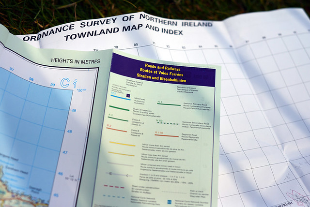
ReplyDeleteAnother thing I like about the OSNI maps is they include a townland map on the reverse.
ReplyDeleteAs an exile, I find the townland names where I grew up as evocative as the geography itself... Mullaghbrack, Mullahead, Tullyhugh, Marlacoo...
The townland boundaries have been interesting to see mapped out. Don't know whether you were still around when this happened, but some years ago they decided to put up signs with townland names all around the place, so that cycling everywhere as I do, I've become familiar with the whole concept even prior to seeing them mapped out. I am told that prior to this, even the locals of the younger generation no longer knew them.
DeleteI don't recall seeing townland names on the signs around where I grew up in County Armagh and I have been back a couple of times in the last year. Maybe this is dependent on the local council. I'll keep an eye open for them the next time I'm back.
DeleteCertainly knowledge of townlands were passed on orally, by hearing people talking about so-and-so who lived in a particular townland.
Maybe things like postcodes, formalisation of addresses by the post office and improved roads have eroded the use of townland names.
Maybe these days you are more likely to hear people referring to someone who lives off a particular road, rather than a townland name.
Maps are a source of excitement and wonder for me, even though (or perhaps because) I've never gone very far. I recently 'discovered' the point where two Ayrshire rivers meet (only about 2 miles from where I live...), only to find that there was a park bench on the opposite bank, so evidently someone else got there before me. I'd to carry the bike (it was impossible to cycle) almost all the way, but hey, I'd never been there before, even if other folk clearly had.
ReplyDeleteIsn't there a Dylan song that refers (sardonically, I think) to 'road maps for the soul'? Suppose that's what we all need, although maybe it's what maps represent to cyclists.
Since the local airfield if home to a glider club I assume the pilot who told you where to get the maps was a glider pilot - we're also probably almost the only pilots who really have a use for maps like the Ordnance Survey ones which give a lot of ground detail. Look at the maps carried in most aircraft and the majority of the information presented is about airspace, airways and radio navigation!
ReplyDeleteHe is both a glider and a powered plane pilot, but the OS maps he uses for recreational walking. For gliding they use aeronautical maps as far as I know.
DeleteNow that you have those maps, you need an intrepid bike like a Surly Pugsley to take you there!
ReplyDeleteI realize I'm several months late but as a fellow map nerd I love this. The Ordnance maps were fantastic when my wife and I were exploring walking trails in Cork on our honeymoon. In the states the USGS maps are of similarly great. My wife makes fun of me for my backup stash of paper maps but one of these that GPS unit won't work and then where will you be?
ReplyDeleteAlso just recently discovered your blog and wanted to express my appreciation. In addition to gorgeous photos of scenery and bike candy (I've never had a photographer's eye so any good pics I take are lucky) you are an excellent writer.